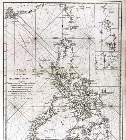
《中国海、菲律宾群岛以及菲丽齐亚和苏禄列岛的海图(A Chart of the China Sea and the Philippine Islands with the Archipelagos of Felicia and Soloo)》是在耶稣会士佩德罗·穆里罗·维拉德(Pedro Murillo de Velarde)1734年编制菲律宾群岛水道图的基础上,结合英国航海调查的新资料而绘制。该图不仅用英文注记三个浅滩的名称,而且抄录了菲律宾群岛水道图上使用的名称:北边的浅滩为Galit,中间浅滩为Panacot,南边的浅滩是Lumbay。而Scarborough Shoal(即黄岩岛),文字注记“The Scarborough Sept. 12th 1748”,意思是斯卡伯勒号于1748年9月12日(沉没),这是英国运茶帆船撞上浅滩的日子。在这幅海图中同时绘出Panacot浅滩和Scarborough Shoal(黄岩岛),证明二者根本就没有关系。

中国海、菲律宾群岛以及菲丽齐亚和苏禄列岛的海图
(A Chart of the China Sea and the Philippine Islands with the Archipelagos of Felicia and Soloo)


